Carlson-IntelliCAD GIS Starter Kit from ESRI

Those currently using Carlson with IntelliCAD are eligible for a new “GIS Starter Kit” from ESRI. The Kit includes:

  • ArcGIS ArcView desktop software
  • A copy of the book A to Z GIS: An Illustrated Dictionary of Geographic Information Systems
  • A copy of GIS Tutorial: Workbook for ArcView 9, Third Edition
  • A 10% discount for the ESRI Survey & Engineering GIS Summit ($325 – standard registration price)

To take advantage of the offer, call 1-800-GIS-XPRT (1-800-447-9778) and request the Carlson-IntelliCAD GIS Starter Kit and please have your Carlson Serial Number available.

You can read more about ESRI’s commitment to survey and engineering services by visiting http://www.ESRI.com/engineering.

Originally posted on Carlson Connection by Jennifer DiBona


A Closer Look at the Drawing Inspector

There are times when you need to know information about an object in your drawing such as its layer, elevation, or direction and distance.  The Drawing Inspector provides a quick and easy way to gather information about drawing entities on the fly.  Simply turn on the Drawing Inspector using the Inquiry pull-down menu, then hover your mouse over any entity.  Soon the information you require will be displayed in a tooltip next to your mouse location.

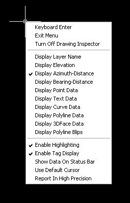
This command is available in any of the Civil Suite products (Survey, Civil, Hydrology, and GIS), or Takeoff.  It works in both software installed on the AutoCAD platform or the IntelliCAD platform.  By default, it will display the layer an object resides upon in the tooltip, but you can change the type of information shown using the right-click context menu.

The right-click context menu displays the options for the Drawing Inspector

When you are finished viewing information about your drawing objects, right-click and choose the Turn Off Drawing Inspector option.  You can also toggle the Drawing Inspector off using the Inquiry pull-down menu.
Originally posted on Carlson Connection by Felicia Provencal


Another Twist for World

I’d like to offer a few other arguments for the use of the DVIEW TWIST routines discussed in North Rotation: Using Twist Screen. The four Carlson DVIEW routines cited:

  • Standard – This option allows you to select a rotation angle using the mouse.
  • Line, Polyline or Text – This option allow you to select an object to set as a view baseline.  It is the most useful when trying to match views to objects such as property lines or road centerlines.
  • Surveyor – This option prompts for the manual entry of a bearing or azimuth for the rotation angle.
  • Restore Due North – This option returns the screen to the orientation where North is straight up.

fall right in line with remarks made by ESRI’s Brent Jones at the 2009 Carlson User Conference who said:

“GIS changes the whole domain for surveyors,” Jones added, “And surveyors need to be ready for what’s coming next — high accuracy GIS. The key is geo-referencing,” he said. “We can use our data to communicate to our world with greater precision over greater areas.”

In my opinion, a User Coordinate System (UCS, by its very definition), takes the data one step further away from being geo-referenced. There are those that would probably argue that having data in a World Coordinate System (WCS) and at assumed coordinates of something like 5000,5000,100 is no better than using a UCS to shift this same data to a proper geo-referenced coordinate system. From a holistic stand-point, I’d tend to agree. However, what sets the WCS vs. UCS argument apart is this simple statement:

All drawings must have a WCS yet not all drawings have a UCS.

When one considers the longevity of information represented in drawings created to this point in time and then reflects on how this information might also be used in the future, I feel it is important to model that information (and subsequently allow that information to be easily extracted) in a consistent and reliable fashion. A User Coordinate System is typically only understood and used by its creator which in turn, limits its use and subsequently increases the risk of liability when the User Coordinate System isn’t known or understood by a “downstream” recipient of the drawing (survey stake-out, machine control excavation, etc).

Side note observation… Is it me or are there some parallels between UCS and custom ARX objects used in other products? When I look at how long the DVIEW vs. UCS arguments have been made, I can only surmise the length of time that will be involved to bring the non-proprietary vs. proprietary data argument to a close. I suspect it’s going to be a long, tough road.

In any event, it is my opinion that standardizing on a single WCS should provide more consistent deliverables when the drawings/projects span multiple people, offices and/or disciplines. When properly adopted, using a “twisted view” of geo-referenced data in a World Coordinate System should provide more feature-rich information now and into the future when our data is mapped onto the Earth.

Originally posted on Carlson Connection by Ladd Nelson


Ribbon vs. Menu… Your preference is??

I was reading a recent AP article that was similar to the article entitled Meet Microsoft’s antidote to Vista and saw the following:

You probably don’t know her name, but if you’re using Office 2007, the sleeper hit of the Vista era, you’re already familiar with Larson-Green’s work.

She was the one who banished the familiar system of menus on Word, Excel and other programs in favour of a new “ribbon” that shows different options at different times, depending on what a user is working on.

Hmmm… I’m wondering if she’d be willing to re-think that decision?

 I’m not sure what it is about the ribbon interface but I cannot seem to get used to it. I’ve tried… I mean I’ve really tried to be productive with the Office 2007 ribbon but continually find myself wasting lots of time searching for a particular command whose location I could find instantly in the traditional pull-down menu system used in Windows and Office applications for the past +15 years. The article also said:

“We want to reduce the amount of thinking about the software that they have to do, so that they can concentrate all their thinking on the task they’re trying to get done,” Larson-Green said in an interview.

The task I’m trying to get done?? I’m trying to figure out where all my favorite old commands went for getting my work done. I’m finding that I’m spending more time thinking and searching for commands and having less time for the task(s) I’m trying to get done. Don’t even get me started on the new default file formats for Office files (*.docx, *.xlsx, *.accdb, etc) and having to Save As for those who haven’t adopted Office 2007 and later.

Side note observation… I wonder how soon it will be until Autodesk decides to release a *.dwgx file format? Perhaps the Open Design Alliance should beat them to the punch.

According to the frequently changing Wikipedia write-up on ribbons:

Microsoft has started the process of acquiring a patent on the ribbon user interface concept[2] and licenses the ribbon design to third-party developers royalty-free, as long as the user interface conforms to the Microsoft’s design guidelines and they can get an approval from Microsoft. The ribbon design guidelines are confidential and an evaluation copy is only available when a non-disclosure agreement has been signed.

The Ribbon has been licensed by Autodesk for AutoCAD 2009

My fear is that when I eventually have to migrate out of AutoCAD 2008 (I’m running the ribbon-less AutoCAD 2008 and IntelliCAD and haven’t even looked at AutoCAD 2009/2010), I’ll be too far behind the 8-ball. Maybe I’m too grounded and comfortable with pull-down menus. I still prefer Windows XP over Vista and suspect I’d prefer pull-down menus in my CAD product like many of comments left at AutoCAD 2009 – How do you use the Ribbon? blog. Perhaps it is time to accept the fact that ribbons are likely here to stay. However, if my CAD productivity takes a hit due to the migration to ribbons like my Office productivity took a hit, I suspect I’m “going to have some ‘splainin’ to do.” Personally, I’d love to have a one-to-one chat with Julie Larson-Green (a.k.a. “Microsoft’s antidote to Vista“) to learn why throwing away +15 years of interface familiarity is/was a good idea.

What do you think?

[polldaddy poll=1552888]

Originally posted on Carlson Connection by Ladd Nelson


Working with Land Desktop or Civil 3D Contours in IntelliCAD-based Carlson Programs


If you are working in an IntelliCAD version of  Carlson Survey or Civil and need to bring in surface entities (contours) from a Civil 3D (C3D) or Land Desktop (LDT) drawing, it’s actually very easy to do. However, it’s not necessarily easy to find on your own. And, unfortunately, it’s in a slightly different place depending on whether you’re using the Carlson Survey or Civil menu.

FYI – If you simply try to “Open” a drawing that has AECC Contour Objects with an IntelliCAD-based program, it may look correct, but the entities will only be the dreaded “ACAD PROXY OBJECTS” that have bogus elevations. These are only good to look at… not work with.

Whether you’re using Survey or Civil, the only thing you’ll need is a drawing file (DWG) containing the C3D or LDT contours for the surface. It doesn’t even need to be opened, you just need to have it and be able to find it. (hey, I’m getting old!).

First, start a new drawing in Carlson.

Then, if you’re using Carlson Civil:

  1. Go to the “Surface” menu,
  2. Select  “Import/Export Surface”
  3. Then, select “Convert LDT/Civil 3D Surface Drawing”.

If you’re using Carlson Survey:

  1. Go to the “Surface” menu,
  2. Select “Import/Export Surface Data”
  3. Then, select “Convert Civil 3D Surface Drawing”.

Next, you’re prompted to “Select the LDT/Civil 3D Drawing to Read”. After browsing to and selecting the LDT or C3D file, pick “Open”.

Next, you’re prompted to to “Select Converted Drawing to Write”. This will be a new DWG file containing the converted data. After browsing to a new location and specifying a new file name, pick the “Save” button.

You’ll see the conversion process in the text window. Once finished, you can open the converted drawing.

What you will find in the new drawing are all of the entities from the original LDT/C3D drawing except that any AECC Contour Objects have been converted to elevated PLINEs and LINEs.

The first step you’ll probably want to take after opening the new drawing is to join together all of the contour PLINEs and LINEs. You may want to “Isolate” the layers for the contours first.

Then use the “Join Nearest” command under the “Edit” menu. Like most cases, make sure to have the “Join Only Common Elevations” and “Join Only Common Layers” options selected.

Originally posted on Carlson Connection by Jennifer Dibona


Carlson + ESRI = Wow!


So, how cool is this? 

At the Carlson User Conference this week in Lexington, KY, Brent Jones of ESRI announced a new grant program in coordination with Carlson Software. The program will bring ESRI products to every IntelliCAD-based Carlson program.

Speaking with Brent on Tuesday, he said that a few of the details have yet to be worked out, but Carlson IntelliCAD users should be hearing details in about a month.

Originally posted on Carlson Connection by Jennifer Dibona

Brent Jones of ESRI discusses ‘Why GIS Needs Surveyors’

Combining all the GIS and land development technologies that exist today is what Brent Jones suggested surveyors do in his keynote address to the attendees at the 2nd annual Carlson User Conference. Jones, PE, PLS, is the Survey, Cadastre, and Engineering Industry Manager for ESRI, which designs and develops the world’s leading geographic information system (GIS) technology.

To help surveyors accomplish this, Jones announced an upcoming grant program to be offered by ESRI for every Carlson IntelliCAD user. “ESRI is very supportive of Carlson’s development on IntelliCAD and we want to support your users,” said Jones of this specialized grant program being developed exclusively for Carlson IntelliCAD users. “We want to help surveyors leverage their existing resources to help in the GIS market.”  With this offer Carlson IntelliCAD users will be able to access GIS technology and jump-start a GIS practice. Read More

Originally posted on Carlson Connection by Karen Cummings


Carlson Software Expands Carlson College™

Carlson Software recently expanded their expert level training program, Carlson College™, and started the Carlson College Training Program. This new program will allow individuals and companies to get training direct from Carlson Software or through the members of the Carlson College Training Program. New members of the Training Program include Harken-Reidar Inc. of Front Royal, Va.; Carlson Desktop Solutions (CDS), based in Austin, Texas; That CAD Girl, located near Raleigh, N.C.; and, for C&G products only, Larry Phipps of the Land Surveyor’s Workshop in Jefferson, N.C. Membership in the Carlson College Training Program is available to any person or organization that makes a commitment to providing quality training on Carlson Software products.

For more information on the Carlson College Training Program or training, please contact Carlson Software at 800-989-5028, email training@carlsonsw.com or visit www.carlsonsw.com/training. Members of the Carlson College Training Program are independent entities from Carlson Software.

Read the entire Press release here.

Originally posted on Carlson Connection by Karen Cummings


Coming in Carlson 2010

I’m not privy to the “official” list of coming updates, but I can share a few things that I know will be in the next release. Most of these come from “wishlist” items I have submitted on behalf of my clients.

The folks at Carlson are welcome to add their 2-cents in the Comments of this post or on Direct From Carlson.

Option for placing building footprint a distance off the building setback line.

Currently, the LotNet command places the building footprint exactly on the midpoint of the building setback line. We heard the request several times to have the option of placing the footprint some distance behind the setback line. It will be in the 2010 release.

C & G Survey

Instead of having two separate survey programs, Carlson will be incorporating C & G as a separate set of menus in Carlson Survey in 2010.

Basic IntelliCAD Menu

If you’re running Carlson on top of an AutoCAD-based program, you have an icon or menu option to switch over to an AutoCAD menu that has basic Draw commands such as line, pline and text and basic Modify commands such as copy, explode and pedit. Although it’s not easy to get to right now, IntelliCAD has a similar set of menus and toolbars. Carlson 2010  stand-alone with IntelliCAD will have a menu item and toolbar icon allowing you to easily switch over to the IntelliCAD menus and then back again to the Carlson menus.

Lookup table of curb slopes for super-elevation transitioning

This new feature will handle curb transitions like those shown in this NC DOT detail drawing.

Originally posted on Carlson Connection by Jennifer Dibona


Poll Question 3/30/2009

[polldaddy poll=1493826]

Originally posted on Carlson Connection by Jennifer Dibona

1 of 1