Survey OEM 2023 Released!

I’ve been pretty impressed with the stability and performance of the Carlson 2023 products so it’s not a surprise that they have released Survey OEM 2023 so quickly.

Wondering what’s new in the latest release? Don’t miss our FAQ: What are the improvements to Carlson over previous versions? 

Anyone who purchased 2022 after 10/1/2022 is eligible for a free upgrade to 2023. Please send Claire or me an email at ContactUs@ThatCADGirl.com and we’ll help you get your new serial number.

If you are interested in running a 30-day trial to try it before you buy it, please reach out to us and we will be happy to send that to you as well. 

PS: Carlson’s and That CAD Girl’s year-end specials are ongoing through 12/31/2022… don’t miss out!


Carlson Software 2023 has been released!

On November 1, 2022 Carlson Software released the 2023 version of their desktop products. With the 2023 release, Carlson is focusing more on performance and stability and a little less on new bells and whistles… I’m guessing the next version will be heavy in the other direction!

Carlson 2023 products will ship with both a preview release of IntelliCAD 11.0 and 10.1 and can also run on top of your separately purchased license of AutoCAD 2018-2023.

Carlson Survey 2023 with embedded AutoCAD (OEM) is expected to be released within the next few weeks but it’s unclear at this time whether there will be a 2023 release of Takeoff OEM.

Any user who has purchased Survey OEM 2022 after 10/1/2022 will receive a free upgrade to Survey OEM 2023. If this applies to you, please Email us and we’ll make sure you get your free upgrade.

If you are currently running Carlson and have an active maintenance contract, you are eligible for a free upgrade to Carlson Software 2023. You will need your 2022 serial number and can use this Lookup screen to find your 2023 serial number.

If you’re a past customer of That CAD Girl, you may be able to find your Carlson Customer ID, serial numbers and maintenance reports on our new customer portal. You can access your portal by clicking here and entering your email address. If you haven’t been granted Admin privileges by your company’s primary point of contact, you may have limited access.

You can read more about the new features and find more information here on Carlson Software’s 2023 product page.

Don’t forget to subscribe to our YouTube channel where you can find our Picks and Clicks videos plus several “Product Overview” recordings that demonstrate features in different programs.

FAQ: What are the improvements to Carlson over previous versions? (a running thread)

And, don’t forget…

Carlson Software 2022


Carlson 2017 Has Been Released!

Late yesterday afternoon Carlson Software released the 2017 version of their desktop software products! Click here to download 2017 and here to see the list of improvements in 2017.

If you are current on your maintenance plan, you can visit this page and use your 2016 serial number to retrieve your 2017 serial number.

If your maintenance has expired or you’re not able to generate your new 2017 serial numbers, please send me an email or request a proposal to find out pricing.


Carlson Software Product Updates 7/1/2015

cad03-13

It’s been about a month since Carlson released the latest build of their 2015 desktop products so I figured it was time to post them here for easy access…

Download 6/9/2015 build here  This link takes you to the page where you can download a full version of the software or updates to bring your 2015 up to date.

Updates to the following desktop modules are included in this file: Survey, Civil, Hydrology, GIS, Basic Mining, Geology, Underground Mining, Surface Mining, Natural Regrade, Field, CADnet, GeoTech, Trench, Construction and Point Clouds. This can be installed on AutoCAD 2007-2015 or with included Intellicad 8.0. AutoCAD 2010-2015 releases are supported on 64-bit Windows. Your Carlson 2015 Serial number is required for installation.

Carlson 2016 will be released before too long. If you’ve let your maintenance contract expire (accidentally or on purpose!), now would be a good time to get back on board. If you renew before 2016 is released, it’ll be cheaper and you’ll receive 2015 now and 2016 when it’s released. Win! Win! Win!

You can request pricing for new licenses or upgrades here

And, while I’m at it, here are the links to download the latest updates for other programs:

Survey 2015 OEM (embedded AutoCAD 2015) – Download the 5/8/2015 build here

Takeoff T8 OEM (embedded AutoCAD 2015) – Download the 3/23/2015 build here

SurvCE 4.0 – Download the 5/15/2015 build here

SurvPC 4.05 – Download the 5/15/2015 build here


Carlson Tip of the Day… List of improvements in Carlson 2015 programs

carlson2015splash


General

  • AutoCAD 2015 – Added support for this new version.
  • IntelliCAD 8.0 – Direct support for 2013 DWG file format. Added 64-bit version. New features including support for dynamic entity reactors, layer states and  improved ddvpoint interface.
  • Google Earth – Added support for exporting 3D Faces.
  • Import 3D View Model File – New command to create drawing entities from a 3D model file.
  • Export 3D View Model File – New command to create a 3D model file from selected drawing entities.
  • 3D Model Library – New command to prepare the 3D models to use in the 3D Viewer commands.
  • Toolbar Manager – New command to save status of toolbars and allow migrating toolbar settings between versions.
  • File Selection – Added list of subfolders within current folder and button to move up a folder level. Added option for warning when selecting a data file that is not within the current project folders.
  • Textures – Added 40 new textures for 3D viewing.
  • Settings File Manager – Added function to compare two settings files and report differences.
  • Leader With Text – Added option for horizontal tick and option to create with Mtext.
  • Join Nearest – Added filters for common colors and linetypes.
  • Join Polyline By Trace – New command to join linework into a polyline with prompts at intersections


Survey Commands

  • Field To Finish – Added special pipe feature coding with ability to create pipe network (.sew) file. For tree feature coding, added option for drip as diameter instead of radius, added option for solid circle for trunk and option for relative tree size for the symbols. Added control for separate layers for the point attribute block and point node. Added new AFIT special code for making a curve tangent through a series of three curve points. Added method for dynamic templates with variable horizontal and vertical offsets by using the OH and OV special codes. Added settings file default distinct point layer prefix/suffix. Added separate text size settings for attribute text labels and point block attributes.
  • SurvNET – Added error report for individiaul observations to track down blunders. Added import for TDS GPS vectors.
  • Edit Process Level Data – Added support for processing with zero horizontal distances.
  • Carlson Cloud – New command for communicating with SurvCE for sending messages, data files and crew locations.
  • Report Distance Scale – Added methods for grid/ground factors on-the-fly in addition to a fixed factor.
  • 3D Transformations – Added 3D coordinate transformations.
  • Point Group Manager – Added method to create point group by offset distance from alignment polyline.
  • Move Point Attributes With Leader – Added controls for attribute order and ability for curved leaders.
  • Import Text/ASCII File – Added method import from text with fixed widths and method to use inclusion/exclusion perimeters.
  • Legal Description – Added method to report station/offset using a reference centerline. Added method for reporting with geodetic mean angle and geodetic distances.
  • Cut Sheet – Added method to get station/offset from the point description coding. Added field for design point description.
  • Offset Points By Interval – New command to create offset points along an alignment.
  • Label Coordinates – Added options to include a description, to use Mtext, to draw the labels at an angle and option for mleader.
  • Draw Legend – Added method to put each symbol or a specific layer.


Civil Commands

  • Draw Profile – For paper space profiles, added method to use an existing layout as a reference template for the new layout. For the horizontal label box, added option for horizontal text in addition to vertical. For pipe profiles, added settings to label inverts by left/right order, added option to draw cutoff style pipe extensions, added option to create labels as MText, added option for flow arrow in middle of pipe, new option for labels above the pipes, added justification settings per label, added setting for separate layer for pipe thickness than pipe profile and option to connect rims with a polyline for a simple surface profile. For Label Line/Point crossings, added option to label elevations at crossings, added method for labeling GIS attributes, added method to label points of selected descriptions within offset tolerance, added option to label CL deflections and added option to avoid label overlaps. Added special CL stations for break point station/elevation labels plus new prefix/suffix settings. For EOP profiles, added new break point and EOP leader style to the start of the labels, added option to label ground profile on road EOP profiles and added controls to select which profiles are EOP, road and ground. For the manhole name within circle option, added setting to put the name and number on separate lines and added the option to auto shift the labels to avoid overlaps.
  • Draw Sections – Added option to label cut/fill volumes per station. Added separate settings for pipe crossing layers for decimals on pipe size, offset and elevation.
  • Draw Plan View Sheets – Added option to set station range to draw.
  • Input-Edit Centerline – Added Fit Curve method to apply speed table to all PIs in centerline.
  • Input-Edit Profile – Added method to apply speed table for vertical curve lengths to all PIs in profile.
  • Label Station/Offset – Added method to use a TIN or grid surface for the elevation reference.
  • Draw Lot Setback – Added method for separate corner side setback amount.
  • Move Spot Elevations – New command to move spot labels and update elevation to new position on reference surface.
  • Line Of Sight Viewshed – New command to calculate line-of-sight from a point and eye height on a surface.
  • Draw Spot Elevations – Added option for label only and option to pick an entity instead of a point.
  • Cut/Fill Labels – For points method, added more options like separate layers for existing and design. For the TIN method, added options for deep cut/fill labels and option for marker symbol.
  • Smooth Polylines – Added method to smooth polyline between selected points.
  • Triangulation File Utilities – Added function to color TIN within inclusion perimeter.
  • Road Stripe Library – New command to setup named sets of road stripes with offsets, colors and styles.
  • Draw Road Stripes – New command to draw linework for road stripes.
  • Linear 3D Object Polylines – New set of commands to manage alignment polylines for 3D Viewer commands for linear 3D features such as fences or guard rails.
  • Label Profile On Centerline – Added label position by left/right in addition to above/below. Added prefix/suffix and station interval settings.
  • Offset 3D Polyline By Grade Table – New command to offset a 3D polyline using the distances and slopes from a template grade table.
  • Road Network – Added settings for station range to process for each road.
  • Mass Haul Analysis – For borrow pits, added offset from road to account for offset travel time.
  • Sections From 3D Polylines – New command to create cross sections from 3D polylines.
  • Surface 3D Viewer – Added option to show contours. Added functions to edit triangulation by swapping edges, adding breaklines, removing points, removing triangles or editing point elevations.
  • Surface 3D Flyover – Surface model is kept in sync with any edits in CAD so that the 3D view is automatically updated. Added method to add models to the scene by screen picking plus the ability to pick models in the scene to edit properties (location, rotation, scale). Added function to record a movie. Added method to map textures by color and method to scale textures. Added run view mode for detached from moving vehicle. Added option to show contours. In pick mode, display real-time coordinate and elevation for mouse position on surface.
  • Motion 3D Viewer – New command to assign path polylines with speeds to 3D models and the camera.


Hydrology Commands

  • Design Detention Pond – New command with all steps for detention pond design plus support for multiple rain events.
  • Pipe Culvert Design – Added method for tailwater by channel or discharge rating and added overtopping analysis.
  • SCS Rainfall Library – New command to define an SCS data reference library for rain events.
  • Rational Rainfall Library – Added import of IDF tables from comma separated text files.
  • Collision Conflict Check – Added support for checking unlimited pipe networks and using the report formatter.
  • Sewer Network Design – Added option for junction loss for pipe connections including laterals. Added method for tailwater at each outlet. New method to set symbol rotation by screen pick. Added graphic preview during .sew file selection.
  • Lateral Design – Allow for multiple lateral connections at manholes.
  • Identify Pipe Polylines – New command to ID or list pipe data assigned to 3D polylines.
  • Import Network From 3D Polylines – Added method to control order of names by design order, elevation or polyline direction. Added method to set rim elevation by depth.


GIS Commands

  • Label GIS Point Data – New command to create text labels or block with attributes for selected GIS attributes.


Field Commands

  • Drivers: Upgraded many drivers from the SurvCE updates.


Geology Commands

  • Define Mining Model – Added Mine Model collection of surfaces for modeling only mineable strata already adjusted for recovery, roof/floor gain/loss and minimum parting. Renamed “Pre-Calc Model” to “Geologic Model”.
  • Geologic To Mining Model – New command to adjust a Geologic Model to make a Mining Model.
  • Drillhole Database – Added support for MS Access .accdb format.
  • DHDB – Added drillhole database import/export to DHDB format.
  • Import From Coal Section – New command to create pit/channel samples from coal sections.
  • Configure Section Info – Added method to set folder for section drawing to allow storing the section info on a server.
  • Import/Export Coal Sections From Text File – New commands to import/export coal sections from/to text files.
  • Grid Files – Added option to store .grd files as binary to improve read/write speed.
  • Grid File Utilities – Added method to call other GFU macros and pass parameters from another macro. Added sin() and cos() functions for grid math. New dialog interface including dialog for creating IF statements. Added 3D window to show grid while modified.
  • Draw Geologic Column – Added method to draw in  3D with strata sections sized based on grade parameters. Also added 3D draw method as 3D lines. Added method to label grade names and added separate layer settings for attribute labels. For labels in 3D, added options for rotate labels vertical and draw label leaders. 3D Viewer Window now shows 3D text generated by Geologic Column.
  • Drillhole Report – Added method to report grades for each strata.
  • Drillhole Core Images – Added method to draw the report to the drawing and added option for labeling depth or elevation.
  • Draw eLog – New command to draw graph of selected attributes from an eLog LAS file.
  • Create Drillhole from eLog – New command to create drillholes with strata classification using the eLog paramters.
  • Trim Isopach Within Fault Zone – New command to isopach elevations and break contours at fault zones.
  • Draw Fault Labels – New command to label fault deltas.
  • Draw Fault Symbols – New command to draw +/- symbols for faults.
  • Apply Faults To Grid – Added method to handle thrust faults. Added method for processing multiple grids at a time.
  • Surface Mine Reserves – Added Adjust Pits Manager for adjusting pit perimeters with real-time quantity updates.
  • Draw Grade Boundary – New command to draw boundary polylines around area with specified grade.
  • Block Model Statistics – Added min/max/average elevation and depth to the report. Added level # to report name.

Surface/Underground Mining Commands

  • Ribbon – Added a mining ribbon for running with AutoCAD 2012 and higher.
  • Import Pit Points – Added method for user-defined input file formats.
  • Import Polyline File – Added method to draw 3D polylines from sequence of top/bottom points for blast holes.
  • Label Property Lines – Added option to label owner or id labels and added setting for label layer.
  • Surface Equipment Timing – Improved calculation speed by 25%. Added method to use table of production targets with variable equipment usage to adjust to meet the targets.
  • Underground Timing – Added option for transparent hatching and for buffer hatching.
  • Dozer Push – Added support for push cut area by closed polyline. Added method for reporting single, average push. Added option to keep existing polylines, to draw centroid symbol and to label total push distance. Added settings for label text size, layer, style, decimals and prefixes.
  • Regrade Backfill – Added bench option to cross section regrade design.
  • Range Diagram – Added dimensions for all angles and distances. Added options to output final profile and to output parameters to sequence file.
  • Design Ramp Profile – New command to create a ramp profile between two surfaces.
  • Ramp Bench Polyline Generator – New command to design bench pits using polylines.
  • Edit Dragline Sequence – New command to edit the steps for pit cuts.
  • Make Solid From Points – New command to create a solid model from a cloud of points.
  • View Solid – New command to view a solid model in the 3D viewer.
  • Draw 3D Mine Model – Added method to make model from coal sections and pillar/perimeter polylines.
  • View 3D Surface History – Added support for displaying TINs.


Construction Commands

  • Define Layer Target/Material/Subgrade – Added support for up to 7 subgrades.
  • Color TIN By Layer – New command to color the surface TIN using the color assignments in Define Layer Target.
  • 3D Drive Simulation – Added method to apply textures to design layers in addition to colors for viewing in 3D.
  • Tag Segments To Skip Linear – New command to tag polyline segments to skip for material linear quantities.


CADNet Commands

  • Merge Raster Files – Added method to automatically select control points.
  • Import SketchUp File To Drawing – New command to create drawing entities from a SketchUp file.
  • Import PDF File – New import engine with ability to use layers for PDFs with layers.
  • Drawing to 3D PDF – New command to create a 3D PDF from selected drawing entities.
  • 3D Viewer to 3D PDF – New command to create a 3D PDF from a 3DX file from the 3D Viewers.


Point Cloud Commands

  • Faro – Added direct import method uses Faro toolkit.
  • E57 – Added support for importing industry standard e57 format.
  • PLY – Added import for PLY format.
  • LAS – Added method to use LAS classification for coloring and selection.


Data Conversions

  • 12D – Added import and export for pipe networks plus support for some more entity types.
  • Canada – Added support for NTv2-NAD27-83
  • Geoids – Added support for Canada CGG2010 and CGG2013n83, Sweden 08_rh2000, Sweden 08_rh70, Poland 2011 and Georgia 2012
  • Iowa – Added projections for Iowa Regional Coordinate System
  • Ireland – Added national grid projection.
  • KOF – Added function to draw linework from KOF files.
  • MDL – Added support for binary data within FSC file.
  • Norway – Added support for N2000 format.
  • SketchUp – Added import for SketchUp models in Surface 3D FlyOver
  • SurvCE – Added import for points with photos in Google KML format as created by SurvCE


Carlson 2015 Has Been Released!

Carlson posted the 2015 versions of their for CAD (IntelliCAD or AutoCAD 2004-2015) on Tuesday afternoon… you can Download Carlson 2015 products with IntelliCAD here. The 2015 versions of embedded AutoCAD products (Survey and Takeoff OEM) will be released later this summer.

If your maintenance contract is current or you have purchased 2014 products within the past 90 days, you’re automatically eligible for an upgrade to 2015. Click here to look up your 2015 serial number using your 2014 serial number.

Click here to review the list of all improvements

Click here to read about updates in Carlson Survey 2015

Click here to read about updates in Carlson Civil and Carlson Hydrology 2015

Click here to read about updates in Carlson Takeoff Suite 2015 – including Construction, CADNet, Trench and GeoTech

There are price increases with 2015 products. Click one of these links if you would like to Request a Demonstration or Request a Custom Proposal to upgrade to 2015 or purchase new software.

Please follow this link to see if you’re eligible for our monthly webinars including CAD and Carlson Tips & Tricks, Intro to Survey and GIS and What’s New in Carlson 2015.


Carlson 2014 Has Been Released

Carlson released the 2014 version of their desktop products today. This includes: Civil Suite, Civil, Survey, Hydrology, GIS, Takeoff Suite, Construction, Point Cloud, Geology, Surface/Underground Mining and Natural Regrade.

The 2014 embedded-AutoCAD versions of Takeoff Suite and Survey have not yet been released.

Carlson Desktop products include IntelliCAD 7.2b and can run on top of full AutoCAD-based products versions 2004-2014. This includes AutoCAD, Map, Land Desktop and Civil 3d. Also, anyone using the FREE IntelliCAD that comes with Carlson is still eligible for a FREE GIS Starter Kit from Esri which includes ArcMap. [This offer ended on 12/31/2013]

You can download Carlson 2014 here.

View the “Survey and Civil – What’s new in 2014” webinar here

If you are using 2013 and are current on your annual maintenance contract, you can click here to look up your new 2014 serial number online. You will need to enter your contact information and your 2013 serial number in order to generate the 2014 serial number. You can find your serial number by opening Carlson Software and going to Help > About Carlson Software > Change Registration.

If you have trouble finding your serial number or would like to know the cost to upgrade any product to 2014, please email me with your request.

Click here for the full list of improvements in Carlson 2014


Register for Carlson’s “What’s New in 2014” Webinar Series

As we’re all getting ready for the release of Carlson’s 2014 desktop products, Carlson Software has scheduled a series of 5 lunchtime webinars to introduce new features and enhancements. See below for details and registration links:

Carlson Survey and Civil 2014
Wednesday, July 24th – presented by Scott Griffin, Director of Sales

Carlson Construction 2014
Wednesday, July 31st – presented by Todd Carlson, Takeoff Product Manager

Carlson Hydrology 2014 and all new Carlson Trench
Wednesday, August 7th – Mark Long, Developer, & Todd Carlson

Carlson Mining 2014
Wednesday, August 14th – Grant Wenker, Director, Mining Division

All new CADnet
Wednesday, August 21st – Jim Carlson, Regional Sales Director

All new GeoTech
Wednesday, August 28th – Dave Sanford, Regional Sales Director


Sneak Preview – Mass Haul Analysis in Carlson 2014

Todd Carlson helped me out with a demonstration of Carlson Takeoff a couple months ago and the company we were presenting to was looking for some particular features in a mass haul analysis routine. They had looked at several other programs as well as Takeoff and had yet to find a solution to their particular issue.

Fast-forward about a month and Todd followed up to let us know that the new functionality had been incorporated into the software and would be available in Carlson Civil and Carlson Construction/Takeoff 2014. This is a perfect illustration of how responsive Carlson is to their customers (or even prospects, in this case).

I asked Todd to write up a little preview of the new Mass Haul Analysis routine we’ll see in Carlson 2014:

Mass Haul Analysis in a nutshell:
Mass Haul Analysis determines the volume and haul distance for groups of net cut and net fill station ranges along a road. The program calculates the optimized cut to fill movements so that the total volume-distance moved is minimized.

New Feature:
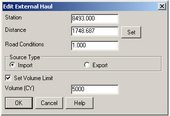
When dealing with multiple external hauls, users can now input the distance (and a “road conditions” factor) a borrow pit or dump pile is from its entry station. The program will then use this information when minimizing earth movement along the road.

For example, as shown in the first graphic below, an image of the area was inserted into the drawing from Google Earth or the Esri Mapping Service. CAD polylines were sketched along the travel paths from multiple pit locations to the project site.

Then, purely based off stationing, borrow pit (A) may be closer to a fill area than borrow pit (B). However, if the distance from borrow pit (B) to its entry station is closer than borrow pit (A)’s, the program may determine to use (B) as the borrow pit over (A) to optimize the earth movement.


Learn more about Carlson Civil and Carlson Takeoff


Carlson SurvCE 3.0 and SurvPC 3.0 Released

From Carlson’s website:

Featuring hundreds of additions and improvements, Carlson SurvCE 3.0 supports the widest range of popular and new release RTK GPS and conventional/robotic total stations of any other data collection software on the market.

SurvCE 3.0 has been released and is now ready for download. Constantly being upgraded, SurvCE features an optional icon-based interface and new Cloud-based messaging, file transfer, NGS monument recall, simplified stakeout methods and powerful GPS measurement averaging and blunder detection in the field (with accuracies in-between RTK and post-processing).

The Carlson SurvCE 3.0 upgrade is offered for just $150 for Carlson customers already using SurvCE 2.0 and above. The price to purchase SurvCE remains the same as it has since 2007.

Literally 100s of enhancements have been built into SurvCE 3.0.


Click here for SurvCE 3.0 Features

Click here for SurvCE 3.0 Screen Shots

Click here for SurvCE 3.0 System Requirements

Click here for SurvCE 3.0 Supported Hardware


Click here to purchase and also, sign up here for our newsletters to be notified of upcoming hardware and software special discounts!

1 of 1